Glaciology is the scientific study of glaciers, ice sheets, snow, and other forms of frozen water on Earth. This branch of geophysics explores how ice forms, moves, interacts with the environment, and influences global systems like climate, sea levels, and ecosystems. With polar and mountain ice rapidly changing due to global warming, glaciology has become a key discipline in understanding the future of our planet.
What Glaciologists Study
Glaciologists investigate a wide range of cryospheric phenomena, including:
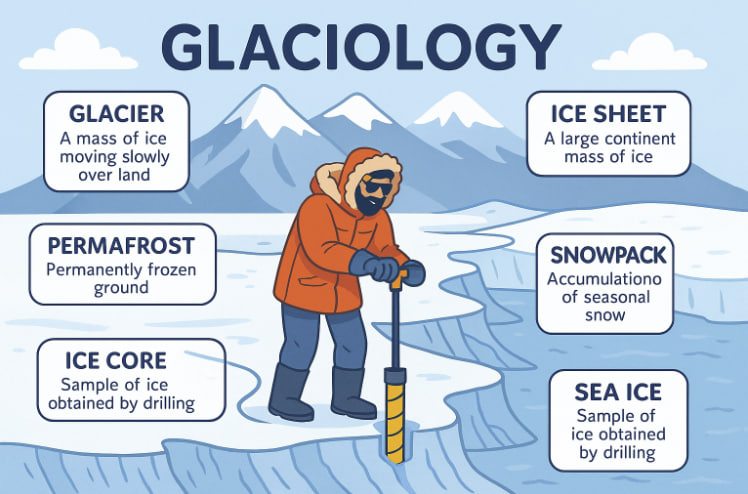
- Glaciers – moving rivers of ice that form in mountains and polar regions;
- Ice sheets – massive, continent-sized bodies of ice (e.g., in Antarctica and Greenland);
- Permafrost – soil that remains frozen year-round, often storing ancient carbon;
- Snowpack – seasonal layers of snow that impact freshwater supplies;
- Sea ice – frozen ocean water that influences weather patterns and polar ecosystems.
They measure how ice accumulates, melts, flows, and how it shapes landscapes through erosion and deposition.
Why Glaciology Matters
- Climate Change Monitoring: Ice acts as a sensitive indicator of temperature changes. Shrinking glaciers and melting ice sheets provide direct evidence of global warming.
- Sea Level Rise: As ice melts, especially from land-based sources, it adds water to the oceans — threatening coastal cities and island nations.
- Water Resources: In many regions, glacial melt provides crucial freshwater during dry months.
- Natural Hazards: Glaciologists help predict and prevent disasters like glacial lake outburst floods (GLOFs) or ice avalanches.
- Earth’s History: Ice cores extracted from glaciers contain ancient air bubbles, offering a climate record stretching back hundreds of thousands of years.
Tools and Techniques in Glaciology
Modern glaciology relies on a combination of:
- Field research (e.g., drilling ice cores, GPS measurements);
- Remote sensing via satellites and drones;
- Climate modeling to simulate ice dynamics and predict future behavior;
- Geophysical methods, like radar and seismic imaging, to map ice thickness and structure.
These tools help scientists monitor changes in real-time and make informed forecasts.
Where Glaciologists Work
Glaciological research takes place in:
- Polar regions: Antarctica and Greenland, where most of Earth’s freshwater ice resides.
- Mountain ranges: The Alps, Andes, Himalayas, and Rockies all host glaciers.
- Laboratories and universities, where data is modeled and analyzed.
Fieldwork is often physically demanding and conducted in extreme environments, but crucial for science and policy.
Glossary
- Cryosphere: The frozen water part of the Earth system, including snow, ice, and permafrost.
- Glacial lake outburst flood (GLOF): A sudden release of water from a glacier-dammed lake.
- Ice core: A cylindrical sample of ice drilled from glaciers to study past climate conditions.
- Permafrost: Ground that stays frozen for at least two consecutive years.
- Remote sensing: Gathering data from satellites or aircraft to study Earth’s surface.