From mapping distant planets to guiding self-driving cars, LiDAR technology has revolutionized how humans see and understand their surroundings. Using beams of light instead of traditional photography, LiDAR (Light Detection and Ranging) allows scientists, engineers, and explorers to capture the world in breathtaking three-dimensional detail.
What Is LiDAR?
LiDAR is a remote sensing technology that uses laser light to measure distances. It works by sending out rapid pulses of light and recording how long they take to bounce back after hitting an object. Because light travels at a constant speed, this time measurement allows computers to calculate precise distances and create detailed 3D maps.
Engineer Dr. Rafael Moreno explains:
“LiDAR is like giving machines eyes that can measure — it doesn’t just see the world, it understands its shape.”
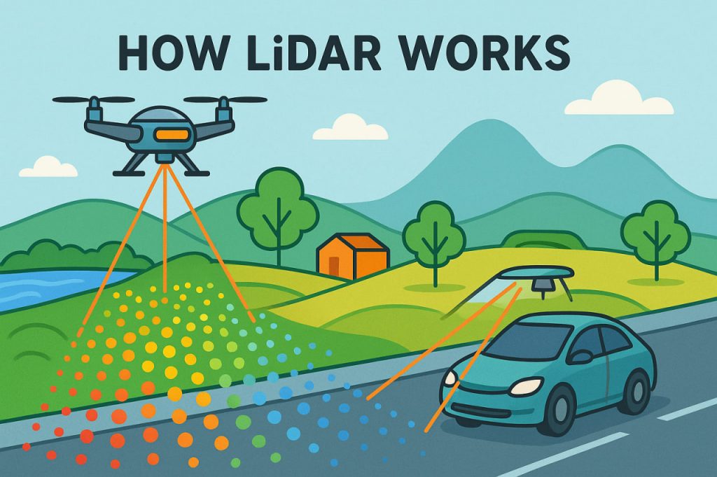
How LiDAR Works
- Emission — The LiDAR sensor emits thousands of laser pulses per second.
- Reflection — These pulses hit objects (trees, buildings, or terrain) and bounce back.
- Detection — The sensor measures the return time of each pulse.
- Processing — Software converts these measurements into a digital 3D model, called a point cloud.
A single LiDAR scan can generate millions of data points, forming an incredibly accurate representation of landscapes and structures — even those hidden beneath vegetation or darkness.
Applications of LiDAR
- Archaeology
LiDAR has revealed ancient civilizations hidden under jungles. In Guatemala, scientists uncovered thousands of Mayan ruins invisible to the naked eye. - Autonomous Vehicles
Self-driving cars use LiDAR to “see” the road, detect obstacles, and navigate safely in real time. - Forestry and Agriculture
LiDAR measures tree height, forest density, and even crop health, helping manage natural resources sustainably. - Geography and Climate Research
It maps coastlines, glaciers, and flood zones with precision, helping scientists track climate change effects. - Urban Planning and Engineering
City planners use LiDAR to design roads, bridges, and buildings accurately within 3D environments.
Advantages of LiDAR
- High precision — accurate down to a few centimeters.
- Works day and night — independent of light conditions.
- Penetrates vegetation — can reveal terrain beneath forests.
- Fast and efficient — covers large areas quickly.
Limitations
- High cost — LiDAR equipment and data processing are expensive.
- Sensitive to weather — heavy rain or fog can distort measurements.
- Large data volume — requires powerful computers for analysis.
The Future of LiDAR
With rapid advances in miniaturization and AI integration, LiDAR sensors are becoming smaller, cheaper, and smarter. They are now used in smartphones for augmented reality, drones for 3D mapping, and even planetary missions — NASA’s Perseverance Rover used LiDAR to explore Mars.
According to space systems engineer Dr. Aisha Khan:
“LiDAR has become humanity’s flashlight — revealing hidden worlds, both on Earth and beyond.”
Interesting Facts
- The name LiDAR combines “Light” and “Radar.”
- Apple’s latest iPhones use LiDAR to improve camera focus and augmented reality.
- In 2018, LiDAR uncovered 60,000 Mayan structures hidden in Central American jungles.
- Airborne LiDAR can map entire cities in a single flight.
Glossary
- Remote sensing — gathering information about objects from a distance using sensors.
- Point cloud — a digital 3D dataset created by LiDAR measurements.
- Autonomous vehicle — a car or drone that navigates without human control.
- Miniaturization — reducing the size of electronic components while maintaining functionality.

